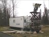
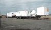
The centerpiece of the data collection/phenomenology effort was the mobile test bed referred to as MAPS, an acronym taken from Millimeter Wave Analysis of Passive Signatures. MAPS provided the data base of passive millimeter wave information concerning terrain, atmospheric, and target signatures needed to support the critical development technologies associated with the STAG program. MAPS' low-bed trailer included an equipment enclosure which was 8 feet wide and 25 feet long.
Photographs of MAPS are shown in the following slides; click on the thumbnails for larger images and explanatory text.
|
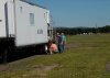
Slide 1: MAPS trailer in the Millitech test area.
|
| |

|
Slide 2: MAPS interior showing controls.
|
| |
|
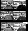
Slide 3: Land mine images passively generated by MAPS at 95 GHz.
|
| |
|
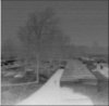
Slide 4: MAPS close-up of land mine field.
|
| |
|
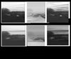
Slide 5: MAPS passive mm-wave 95 GHz images compared to video images.
|
| |

|
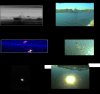
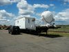
Slide 6: MAPS rocket stand measurement configuration at Stennis AFB.
|
| |
|
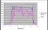
Slide 7: Plume signatures obtained at Stennis AFB.
|
| |
|
Slide 8: MAPS images of cloud-related sky noise.
|
| |

|
Slide 9: Final set of MAPS images, spring 2003.
|
| |
|
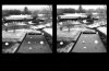
Slide 10: Close-up of 60 GHz MAPS image.
|
| |
|
Slide 11: MAPS at Westover AFB.
|
| |
|
Slide 12: MAPS and RAVIN at Westover in 2003.
|
| |
|
Slide 13: Reconfigured RAVIN-SL5 at Westover in fall 2003.
|
| |
View 
![[Doc Ewen looks into the horn antenna, 1950]](ewen_horn1s.jpg)
![[Doc Ewen and horn antenna, 2001]](ewen_horn2s.jpg)